


Postcode Wall Map Of North of England UK GB Newcastle-Leeds-Manch-Liverpool D4 Laminated
Description
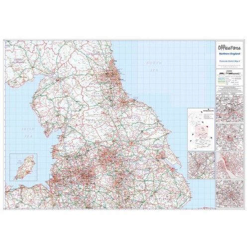
District Map 4
This postcode district map displays the complete first half of the Postcode (or Outward Code) for Northern England including Newcastle, Leeds, Sheffield, Manchester and Liverpool. This map covers the following area:
North: Hawick
South: Nantwich
East: Bridlington
West: Bangor
This postcode map is the fourth of six pre-defined sheets that covers Britain at a scale of an inch to 5 miles. The District maps include all of the Postcode changes from the most recent Royal Mail Postcode Update. The Area and District boundaries appear prominently in red with County and Unitary Authority boundaries displayed in purple. The map base shows motorways, primary and ‘A’ and ‘B’ roads and features conurbation shapes highlighting major towns and cities.
This postcode District map also contain large scale city plans for Newcastle Upon Tyne, Leeds, Sheffield, Manchester and Liverpool to give you a more comprehensive view of the postcodes within this area.
Specifications:Size: 91 x 127 cm (35 x 50 inches)
Scale: 1:320,000
City Inserts: Newcastle, Leeds, Sheffield, Manchester & Liverpool
Laminated providing a dry wipe surface We have our own friendly drivers for deliveries to the Forest of Dean and Wye Valley, Gloucestershire, Herefordshire, Monmouthshire, Gwent, Bristol and surrounding areas and for delivery further afield we use an excellent next day courier service. Please visit our Deliveries and Returns page for further information.
Specifications
Map Marketing
Planners
Maps
No
Office Star Group
Maps

